|
|
|
|
|
|
|
|
 |
|
 |
|
|
 |
|
|
|
Kosrae State, FSM - April-May 1999
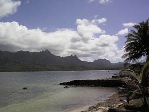
The Sleeping Lady - Kosrae, FSM
The photograph has her in profile, her head to the right, her two breasts roughly center, her hands folded on her belly center to left. According to the story, the gods were angry with a woman so they laid her in the sea in a sleeping position and turned her into the island of Kosrae. She was menstruating at the time, which accounts for the only patch of red soil on the island --- Finlesr Lat. This site is in the jungle, at the place that would have been between her legs. Men go here to collect the red soil from this sacred place and use it to make the paint they put on their canoes.
April 28, 1999
I arrived on Kosrae today. I am at the Trade Wind Hotel on Leluh. It is a one-room, eight-sided affair. I am less than a 5 minute walk from the ruins. Tofol is the government and administrative center of the island. It has the government offices, the banks, the post office, a couple of restaurants, the high school, the college, and such. The place I am in is like a big hotel room, except it is one of about 5 separate little cabanas. It has a kitchen and bathroom, as well as the main room/bedroom. There is no TV, although there is a SeaBees Camp that apparently shows movies every night (in Palau, they used to advertise their movie schedule for the week). The room/cabana is furnished, including pots, pans, dishes (china), sheets, towels. Stan says they even clean your room for you. The telephone, unfortunately, is across the room from my work area on a short phone cord, which means hauling the laptop over to the phone cord when I need to send e-mail.
I have a van. Berlin signed out one of the office cars to me for after hours, on the condition that it must be at the office during office hours. I think I can handle that.
My neighbor, David April, knocked on my door soon after my arrival, delivering a pot of food, just because he knew I was probably exhausted. He is a 72-year-old professor of business/economics at the College of Micronesia. He has his suits laying outside on chairs in the sun airing out. Anyway, it was very nice of him to offer some food. This reminds me that in the airport I met an Australian volunteer with the Development Bank of FSM. His name is Graham, and he is a retired banker called in to advise and consult with the Development Bank. I was telling him what I was doing; I found one of his questions a bit odd --- do I get satisfaction out of what I do? I think he enjoys what he is doing, and was proud of the fact that in the two years he has been doing this, the number of bad loans has dropped. I told him what I do, how it is pioneering work insofar as it is providing a foundation of future archaeology here --- my maps, my books, my reports end up being used by whoever comes out this way in 10, 20, or more years down the line. Or so one likes to think.
This program of Australia's --- matching professionals to programs in Micronesia --- seems like it really works. The Archives in Yap has another guy from Australia, doing the same thing there, assisting the archives, advising and consulting with them over their program. They also have a kind of Peace Corps program too, which takes people like Donna the Australian and essentially provides an extra hand in places like the U.S. Peace Corps does. Anyway, it sounds like it works. Australia apparently does this throughout this region of the world. The banker had been in Sri Lanka for nearly four years on this program. His wife was with him then (yes, the program pays for her passage too), but she apparently got a very nasty case of dengue fever, so bad that she had to go home with a nurse at her side. He said she still isn't quite well, and it has been at least a year; that is why she isn't with him on this trip.
Back to Kosrae --- Stan (one of the field people in the HPO) gave me a quick tour of this place, took me shopping for foods, and showed me the office before he left for the weekend. Attached to the office is a small museum that Berlin Sigrah, the historic preservation officer (same position as Tharngan), started --- on his own initiative, mind you. It is a really cute little place, with real charm. It looks like a one-man project, someone who wants to show off the materials from the past because they should be. There are all kinds of adzes, pounding stones, these incredibly shaped food pounders (like some of the Polynesian stuff, you know; that elaborate), bullet casings, pictures of explorers through Kosrae, a piece of tol cloth (really intricate weaving), models of boats and houses, and other stuff.
April 29, 1999
I think the heat wiped me out today. Either that, or the last couple of days are actually catching up to me. I went to the Bank of Hawaii today to make sure I had money for whatever I needed this weekend. It is like that wherever I go; the first couple of days are spent buying supplies, and it usually means spending a lot of money all at once. So, there is a line at the bank, only it is not standing up, it is sitting down. The bank has a whole bunch of chairs lining the wall (it is a small place), so that is where the customers wait, and they move up chair by chair, as the line moves forward. The main town, Tofol, where all the government offices are, is like a hub of activity, in a way. It looks like a Colonia-town, with the architecture and everything. You could almost imagine yourself back in the Trust Territory times; I wonder too, if it has really changed much since then. That is something I am going to have to ask Stan about (one of the field guys in the HPO).
Everyone drives very slow. Maybe 25 mph at the most. Taxis, apparently, drive the fastest. I even got passed by one today. Oh, and there is also only one main road on the island; you can't get lost.
April 30, 1999
Just figured it out --- the reason the heat got to me more quickly than usual. We are sitting at 5 degress North latitude. We are closer to the equator. Pohnpei was about 7 degrees north, and Yap, I think, was around 9 degrees north. It definitely makes a difference.
Stan handed me a schedule of work when I first got here, but looking it over last night, it is a bit ambitious. He has data recovery (the full-blown excavation, as opposed to quick sampling) scheduled for one week each at various sites, including Yenasr Islet --- the sacred islet of Leluh. It is the place were high chiefs' bones were disposed, plus it is the islet of magicians and priests. It is the one I have been looking forward to, and a week is simply not enough time. Of course, come Monday, we will go over the schedule in greater detail.
It has never been mapped; no, I take that back, Ross Cordy was supposed to have done a brief sketch map, but I don't think there is a real, honest-to-god map. That is a necessity, along with looking at construction, getting some sort of datable deposits, and stories behind the place. Especially the stories to go along with the archaeology.
May 1, 1999
I have had an adventure today. First swimming. No one was at the swimming hole, but then it was also in-between church services. From what I gather, people go to multiple services on Sunday. I stayed awhile, dried off, watched the fish and the sea slugs. Sea slugs are really weird. There were a lot of them, at least three different kinds, too. They move really slow; in fact you don't see them move, but if you look away for awhile, then look back, you will notice them in a different position. In that time you didn't look, they moved. I think you need to have a slow-motion, frame by frame camera to get the subtleties of their movements.

Walking back, looking at Leluh from the end of the causeway, the artificial island and its growth from the volcanic island to which it is attached; thinking about the earliest date of it so far (about 900 A.D.; Nan Madol has an early date in that neighborhood too), I was beginning to think that maybe Leluh came first. It is a nearly solid extension of land, with some canals through it. But Nan Madol is a series of islets, as if it is the next step up in architecture --- go through the learning stages first, that you don't have to build solid fill land outward, but can conserve your materials and build focused platforms or artificial islets with canals between. Anyway, those were my thoughts as I am wandering down the road.
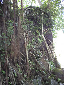 The ruins are a marvelous piece of work. You get a warmth, a humanness when you walk through there. Nan Madol is not that way; it is kind of a cold, calculated construction, impersonal in a way, and definitely uninviting. Maybe the other islets of Nan Madol are different, but I suspect not. And, it kind of reminds me of the people. Pohnpeians were nice, but at the same time, there is this feeling of drawing lines or putting up walls, like this is my space that is yours, this is a demarcation, you don't cross it I don't cross it, all with a kind of coldness attached to it. But Leluh is not; like the people there is a warmth or a kindness about it, a benevolence, and an oldness. Maybe it is just my imagination running wild, but there are these huge breadfruit trees all over the site, and these incredible banyans --- they are most impressive and they add the human factor to it all. I know there were also food trees, like breadfruit, at Nan Madol, but they didn't particularly add anything to the site. Here they do: they say people lived here, ruled from here, were buried here, and went on living here. The ruins are a marvelous piece of work. You get a warmth, a humanness when you walk through there. Nan Madol is not that way; it is kind of a cold, calculated construction, impersonal in a way, and definitely uninviting. Maybe the other islets of Nan Madol are different, but I suspect not. And, it kind of reminds me of the people. Pohnpeians were nice, but at the same time, there is this feeling of drawing lines or putting up walls, like this is my space that is yours, this is a demarcation, you don't cross it I don't cross it, all with a kind of coldness attached to it. But Leluh is not; like the people there is a warmth or a kindness about it, a benevolence, and an oldness. Maybe it is just my imagination running wild, but there are these huge breadfruit trees all over the site, and these incredible banyans --- they are most impressive and they add the human factor to it all. I know there were also food trees, like breadfruit, at Nan Madol, but they didn't particularly add anything to the site. Here they do: they say people lived here, ruled from here, were buried here, and went on living here.
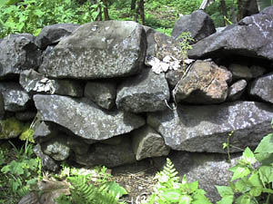
Leluh, path between two breadfruit trees
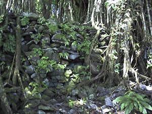
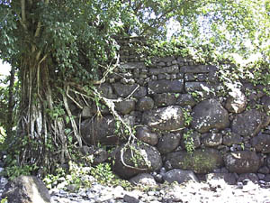
Leluh, wall with banyan tree

Leluh, Foton corner
Leluh, Kinyeir Fulat
Leluh wall construction
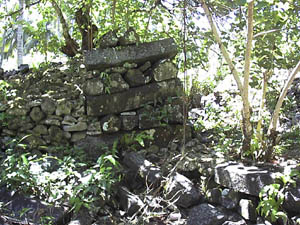
Leluh, royal tomb
Leluh, royal tomb detail

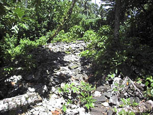
Leluh, seka pounding stone
A bit later I ran into my neighbor, the 72-year-old man who is teaching at COM, and together we go through the ruins of Leluh. They are fabulous. It is a small core of the whole place that is now preserved, with signs up describing the tombs and such. I guess this is as much as the government could do --- people have settled on the remainder of the place, you can't exactly kick them off. There are massive coral slab walls, huge walls of columnar basalt, giant breadfruit trees all over the place, and amid the tombs, huge banyans, even bigger than those I ran across on my site in Yap. But, leaving the ruins, I got bitten by a dog. She had just had puppies, and was protecting her litter. Damn though. I was truly upset --- I have never been bitten by a dog, and all I knew was one minute we were talking about the ruins and the next minute I had a dog attached to my leg.
So, my neighbor flags down a policeman, complains about the dog, and has the policeman take me to the hospital for treatment. The doctor there is a local woman, and totally marvelous. She was one of about 8 or 10 who had the luck to get enrolled in this program sponsored by the Australian government for training medical practitioners in the islands. She graduated in '97 and has a degree in surgery and pharmacy, and a couple of other things that I don't remember. I remember this program in Palau, where my friends working in the hospital would speak periodically about their new rotations of students; I thought it was a good program because it took locals, trained them and placed them back into the hospital.
Along the way today I found out why there is no cooking on Sundays here. It was the missionaries, of course, who said there was to be no smoke on Sundays. So, meals would be prepared very early in the morning, before the dawn so that there would be no smoke by the time the sun rose. Today, however, with electric stoves, refrigerators and what not, they are getting a little bit more lax about that rule. Although you may not fish (it is a misdemeanor) and you may not drink alcohol.
I have been reading from one of the volumes of the History of Micronesia series. It contains all sorts of ships' logs, letters from navigators, an interesting couple of letters from this guy William Adams --- a pilot who was shipwrecked in Japan about 1600. All I keep thinking about these guys, including the O'Keefes and other traders, was that they faced sort of similar circumstances --- off and away from their families, trying to earn a buck, only ended up working their butts off for minimal returns. Of course, they faced the uncertainty of whether they would actually return home or not --- too many ships have been lost at sea. And, what surprised me was to find out that in the 65 years that Spain had operated out of Manila --- as her active port and capital for this part of the world --- 50 of those years were considered a complete economic loss, while the other 15 never produced enough to make up for those losses.
May 3, 1999
There is a really cool site, as far as I can tell, on the other side of the island, in Walung. It is on the coastal strip, an isolated architectural compound. A big place all by itself. If there was ever a place that had the real potential for early deposits, it is there.Yenasr is neat too; I know it is a small islet with architecture. But as I recall, it is unique architecture, and there is no map of it (as far as I know; because I don't think Cordy ever did one and I know Hambruch never did). We would have to get below the architecture for some possible dating material. Then, the question is, is there money for dates?
Today was the official visit with the director of the department which houses the HPO, plus some site tours --- a Japanese radio tower, some prehistoric sites with lots of stone walls --- like at Leluh, places that extend into the mangroves on filled land, and of course, trips to see their signs put up at various historical sites. They are very proud of their signs, and they should be. They are rather charming --- giving the name of a place and a short history, all hand-lettered, trying to look professional as best as they can.
May 4, 1999
Today was more site tours, this time around to the north side of the island. It was really interesting. It is definitely different than western Micronesia, and perhaps just a smidgin more comparable to that in Pohnpei (although, if I had my druthers, I would leave Pohnpei out of the picture altogether). There are these massive basalt walls of both boulders and columnar basalt that form architectural compounds, surrounding one to several house platforms. And these compounds ring the island in clusters of settlements or villages; but, so far only the coastal plain has been surveyed, so there is no telling what is in the interior of the island. There was one site we went to today where the entire coastline, as it abuts the mangroves, was reinforced by a basalt retaining wall.
We also went to the end of the circumferential road (well, it doesn't go all the way around the island, but it will eventually). On the north end, it stops on a bridge. This bridge to nowhere. It crosses a stream and then stops on the other side. It is pretty funny looking, and right now people use it as a parking space when they go swimming in the stream.
I have been thinking more about Leluh, trying to come up with a reason why it is different from Nan Madol, and also sort of similar. Partly it is because of the extent or nature of the fill --- over the tidal flats off Leluh island --- as well as the livability of this place. It has a real human quality to it, unlike Nan Madol, and you can imagine people living out their lives in a place like this. It was the home of the paramount and high chiefs, and was served by two channels through the lagoon. But it was not an isolated place; it was definitely a center of activity and the focus of island life, and perhaps that is one of the biggest differences between it and Nan Madol --- no matter where you go on this island, all roads lead to Leluh. That is what gives it its strength of character, I believe.
Now the question is going to be if the site on the other side of the island, in Walung (no road to it, we have to get there by boat), is something of an administrative center for that part of the island. I am told it is a very large, architectural compound, and isolated. In my mind, I see it as a Fortress of Solitude (maybe my imagination running wild, I admit). There are no other sites nearby --- which is unusual, as most sites are clustered into communities or villages of sorts. I am hoping Stan can arrange a trip to it tomorrow; I want to visit it before we start anything there, just to get an idea of what we will be facing. It is on a coastal strip, with sandy soils. If there was any place for early settlement, it would be in a place like this. The environment, at least, suggests a possibility also of recovering pottery --- the only pottery that has ever been recovered on this island is from Leluh, near a point where the land meets the fill, and it was apparently from a time before the construction of Leluh --- from the description of the place. This pottery seems to disappear about A.D. 500, although its appearance is in question, perhaps 2,000 years ago.
These are walled compounds that are strung out over the landscape. You might have a little cluster of walled compounds one place; go a little farther and you have another few compounds clustered --- not adjoining, just in relatively close proximity. Stan says they occur on flat land, or benches along slopes and river/stream drainages, and they are almost always in close proximity to a drainage of some sort. The clusters are probably for an extended family, each family with its own compound. And these clusters are part of a larger community, with a community meeting house. I saw one map in a report that shows these compounds generally at the transition between the coastal plain and the foot of the mountain slope. But I also noticed that as you move upstream from them, there are clusters of non-walled platforms. The topography itself suggests that there could indeed be more further upstream as well as on the flattened ridgetops. But, no one has looked up the drainages or on the ridgetops.
On the south end of the island, we went to Utwa Harbor. There is a planned marine park here, but it is more than just a marine reserve. It will involve forestry and the preservation of the wetlands, and it will also include the preservation of various cultural sites along the mangrove channels as well as additional protections for the Leonora, Bully Hayes' ship that sank in 1874 --- he was a notorious pirate in this part of the Pacific.
The south end of the island ---
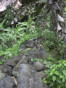
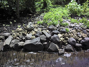
Alik Livaie site in Utwa municipality --- a small walled compound. You can see the thick walls (basalt cobbles and boulders) partly covered with vegetation. To the left is the edge of a house platform (a raised basalt cobble and boulder construction) also covered in part with vines.
Alik Livaie site, Utwa
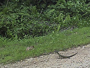
Monitor lizard in the road; he was about 2 feet long
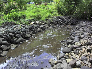
Tafwewan --- another larger walled compound. This is just one of the walls down its length, and a detail of the construction.
Tafwewan wall
Tafwewan wall detail
As it is, Stan was telling me that dive guides cannot take divers or tourists to any of the wrecks (WWII as well as whaling and trading ships, and other, I think) without first getting permission from the office, and often either Stan or Nena will go with them. Both of those guys are certified divers --- they have to be, he said, because they have underwater wrecks that are also historical resources.
May 5, 1999
Loacl is a village community. The photographs show the canoe landing in the mangrove --- the landing place plus an attached platform that juts out into the mangrove. When the paramount chief in Leluh needed something, the first person he would contact would be the chief responsible for Loacl.
Loacl landing
Loacl canoe slip
The Japanese built up a platform on top of the platform here as the foundation for a sawmill.
Wiya Bird Cave --- an important cave in traditions. It houses a local swift; they nest by the hundreds there. It was a source of water in the past, many stories, and, during Japanese time, guano. The terraces were probably built by the Japanese for access to the mud --- the whole back of the cave is a giant pond into which the birds drop their drops. Apparently when the Japanese were mining this place, they dug up a lot of bones and skulls. Myths say this place was the home of giants, who would go out fishing with nets at night. For several nights, a Kosraean would sneak out with the giants (unbeknownst to them) and see how they fished. He then took this knowledge back to his people, and that is how Kosraeans learned how to fish with nets. Other stories have a young man who travels into the depths of the cave, against the advice of his elders. The cave is supposed to house a blind ghost or magician, so the stories go that this young man and magician become friends and have several adventures. Other stories say the cave connects several parts of the island as tunnels, including Walung (the cave is in the northeastern part of the island; Walung is in the southwestern part).
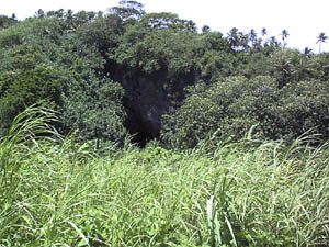
Wiya Bird Cave entrance
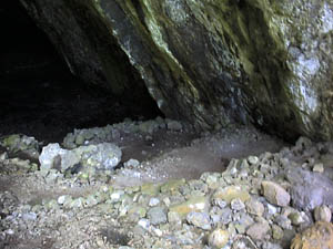
Wiya Bird Cave terraces
Yoshi Sinoto excavated a small area of the cave in 1980, and came up with a date of about A.D. 1350 for a mid-level deposit. He noted that there was a very nice stratigraphy in the small section he excavated (toward the top of the terraces in the picture), with a buried platform, small hearth or oven deposit, and shell and midden layers. He commented that he could not excavate any deeper given his time constraints, but that the deposit went deeper and had the potential for some very interesting archaeological deposits.
This is a taro patch with soft taro (the smaller leaves) and another kind of taro (the bigger leaves).
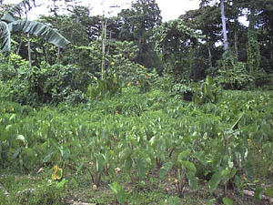
Soft taro
Just beyond the taro are tall straight trees. These are canoe trees --- what canoes are made of here. These trees like wetlands.
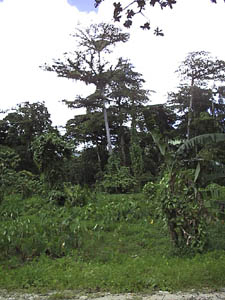
Canoe trees
Kosrae reminds me of Kauai, only on a smaller scale. There, much of the settlement was on the coastal plain --- but again, virtually no work in the interior of the island has been done. The big difference is that Kauai's coastal plain is much bigger than the one here; here it is not only narrower, but mangroves take up a good portion of it.
The Wiya Bird Cave was a big controversy about 1980 and '81. It was almost destroyed for the rock --- to create gravel to pave the new runway at the airport --- were it not for the intervention of the local representative of the historic preservation office (then under the TT government), who called in the TT archaeologist (Ross Cordy) and TT HPO (Scott Russell). Russell was nearly going to let the cave be destroyed, so long as data recovery was done first. Cordy was sent to the island for his estimation of the best way to proceed, and was convinced by Teddy John (a legend out this way, as one of the best, strongest, and most charismatic of HPOs in Micronesia --- unfortunately now dead) that the cave was highly significant to Kosrae, its traditions and culture. So the fight began. And ended with its preservation, although the rock quarry was put in adjacent to the cave.
Next: Leluh and Walung
|
|
|
